All Glaciers of the Month
In the Shrinking Glaciers Project page, we present a featured Glacier of the Month (an example of either a famous or a less-known glacier that has changed over time, illustrating some of its characteristics and comparing old and recent images) every month. To avoid making it very long, we just show the last ones in that page. All the monthly posts on this subject are shown here for reference.
-
October: Monte Perdido Glacier
Monte Perdido, the highest peak in the Ordesa y Monte Perdido National Park at 3,355 m asl, rises in the province of Huesca, northern Aragon, Spain. Its exceptional biodiversity drew naturalists and mountaineers throughout the 18th and 19th centuries, captivated by the fact that it forms the tallest limestone massif in Europe.
On its northern flank lies the Monte Perdido Glacier — one of the few remaining glaciers in the Pyrenees and a defining emblem of the national park.
The intense heatwaves of the summers of 2022 and 2023 triggered a marked retreat of the Pyrenean glaciers. Projections suggest that within the next one to two decades, these glaciers may vanish entirely.
Recent measurements from the Monte Perdido Glacier underscore this alarming trajectory: between 2011 and 2023, its ice volume has shrunk by 20%, and the glacier has fractured into two distinct sections.
Additional measurements taken in 2023 revealed that the glacier had receded by an average of 3.8 m, with the eastern sector thinning by as much as 8.1 m. The effects of climate change on the Monte Perdido Glacier are increasingly severe: it has now been officially listed in the Global Glacier Casualty List — an international registry that tracks glaciers deemed irreversibly endangered or already lost due to global warming.
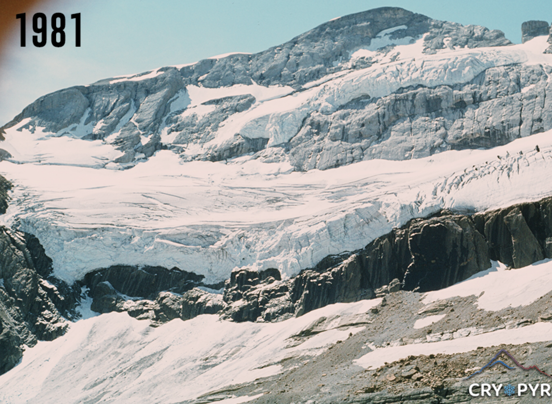
1981 Courtesy of @CryoPyr 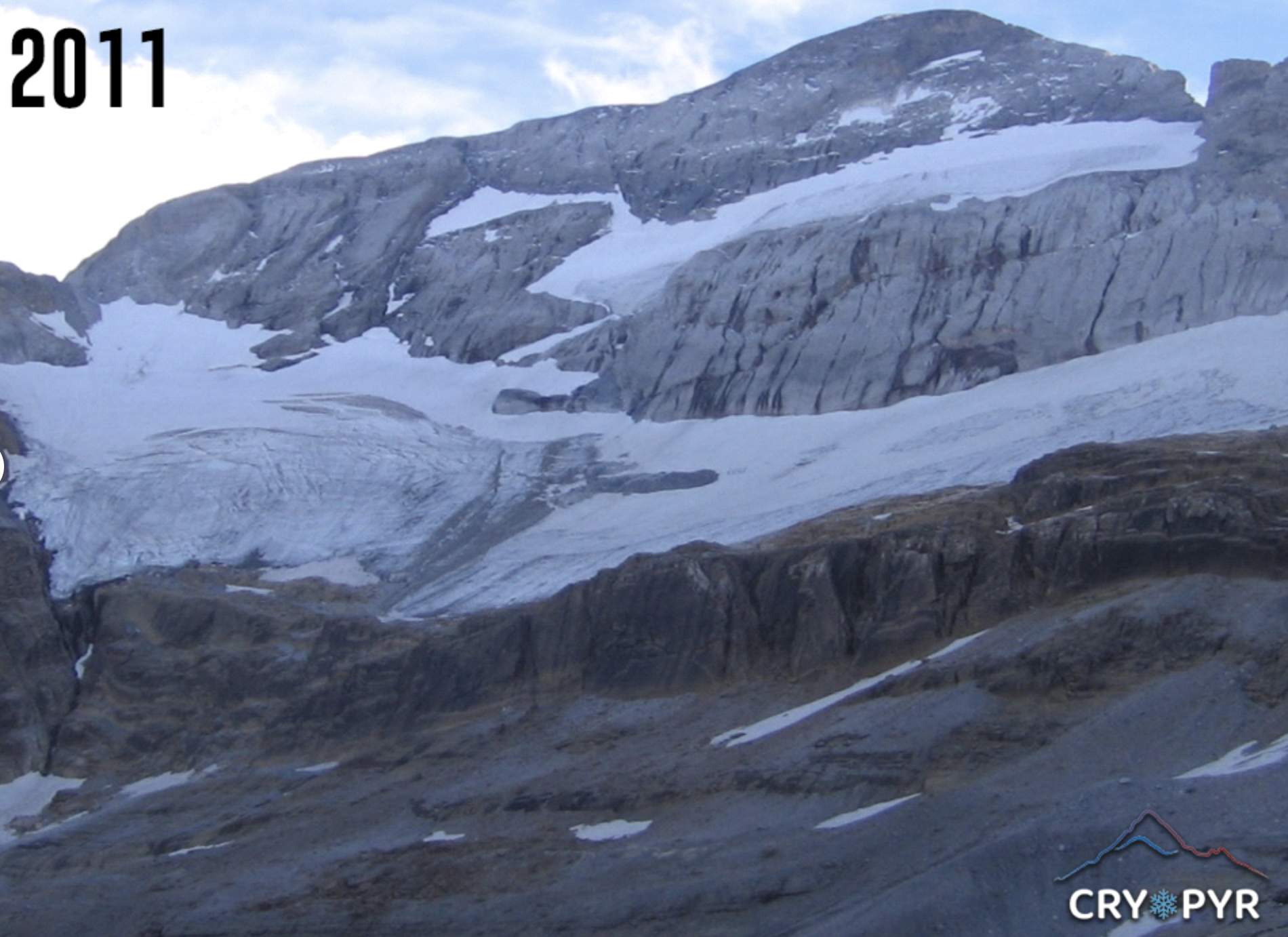
2011 Courtesy of @CryoPyr
-
September: Girose Glacier
The Girose Glacier lies at the base of La Meije (3,984 m asl), a striking peak in the Écrins Massif, a high mountain range in France. To its west stretches the Mont-de-Lans Glacier, while the Vallon and Râteau Glaciers flank it to the east. Pic de la Grave (3,667 m asl) overlooks the Girose Glacier, in a region distinguished by several ice domes—among them, the Dôme de La Lauze which rises to an elevation of 3,568 m asl.
The Girose Glacier is one of the last remaining large glaciers in the Alps. As of 2022, it spanned an area of 4.63 km². However, it has been steadily retreating, with noticeable melting occurring each summer. Since 2003, this process has accelerated significantly. Between 1983 and 2014, the glacier lost approximately 15% of its surface area (Rabatel et al., 2016).
The Girose cable car, once used to transport visitors to the glacier, is currently out of service and is slated for dismantling. This moment could serve as a poignant opportunity to reconsider our perception of this legendary site—a place that evokes both wonder and reverence for the high mountains.
Yet, the glacier is also part of the third section of a cable car development project that has sparked considerable debate. Since 2018, Mountain Wilderness France has actively campaigned to protect the landscape and its biodiversity through the citizen-led initiative La Grave Autrement.

1920 Courtesy of Yvon 
2023 Courtesy of Mathieu Crétet
-
July/August: Gepatschferner Glacier
The Gepatschferner Glacier (Vedretta della Croda) is located in the southern part of the Kaunertal Valley, Tyrol, western Austria, and has a small portion that extends into Italy, specifically into South Tyrol. It extends over 7.8 km in length and covers 16.6 km² and is the second largest glacier in Austria after the Pasterze Glacier. Together with the Kesselwandferner, it forms the largest contiguous ice surface in the eastern Alps.
The glacier culminates to the northwest in the Weißseespitze/Cima del lago bianco (3,526 m asl), whereas the three peaks of the Hintereisspitzen (approximately 3,450 m asl) border the Gepatschferner Glacier to the southeast.
The glacier is receding about 100 m/year, making it the fastest melting glacier in the Alps. Since around 1850, the Gepatschferner Glacier has lost about half of its mass. Where the glacier tongue once ended, at the Fernergarten or Fernergries, stands the Gepatschhaus 1,928 m asl), built in 1873, the oldest Alpine Club hut in Austria.
Glaciers are the world’s largest freshwater reservoirs. The Inn and Rhône rivers, both originating in the Alps, are prime examples of rivers fed by glacial meltwater. One of the Inn’s tributaries is the Fagge river, that drains the Gepatschferner Glacier.
On July 13, 2025, an action led by Mountain Wilderness Germany on the Gepatschferner Glacier in the Ötztal Alps called for the uncompromising protection of existing glaciers and the implementation of effective climate protection measures. The action was organised because the Kaunertal glacier ski area is planning to expand beyond the existing ski area boundaries in the direction of Weißseespitze and Gepatschferner. The expansion is intended to enable skiing even when glaciers are receding. The campaign received support from members of Protect Our Winters Germany.
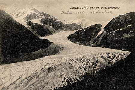
1904 Courtesy of Sammlung Gesellschaft für ökologische Forschung 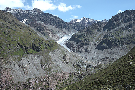
2017 Courtesy of Sammlung Gesellschaft für ökologische Forschung
-
June: Schneeferner Glacier
The Schneeferner Glacier is located on the Zugspitzplatt, a plateau sloping downwards from west to east, south of the Zugspitze (2,962 m asl), the highest mountain in the Bavarian Alps. Until 2022, there were three glaciers on the Zugspitze: the Höllentalferner, the Southern Schneeferner and the Northern Schneeferner.
In September 2022, the Bayerische Akademie der Wissenschaften announced the Southern Schneeferner had lost its glacier status. Since then, it has been referred to as “Toteis” (dead ice). After the extreme summer heat that year, its ice sheet was less than 2 m thick in most areas and did not even reach 6 m at its thickest point. Its area had halved to about one hectare between 2018 and 2022.
With an area of around 30 hectares, the Northern Schneeferner is the largest glacier in Germany, and being located at a high altitude, it is accessible well into the summer months. However, it is expected to disappear within the next 10 to 15 years. Climate change is the primary driver of glacier retreat worldwide. Saharan dust and black carbon accelerate the melting process.
Glacier changes are a visible and well-documented indicator of global warming and significantly alter landscapes. Although the retreat of Bavarian glaciers is unlikely to cause an immediate water shortage, it should nonetheless be regarded as a stark indicator of the broader impacts of climate change. It will undoubtedly lead to shifts in local flora and fauna. In the Alps, temperatures have risen by nearly 2°C since the late 19th century, which is almost twice as much as the global average.

ca. 1900 Courtesy of Unknown Author* 
2013 Courtesy of Bbb-Commons* *https://commons.wikimedia.org/
-
April/May: Lang Glacier
The Lang Glacier, situated at an altitude of 2,077 to 3,890 m asl and spanning 6.5 km*, is a valley glacier located in the Lötschental valley, in the southern Bernese Alps in the canton of Valais, Switzerland.
Positioned on the western side of the Lötschenlücke, it descends into the Lötschental valley. Since the mid-19th century, the glacier has retreated by approximately one kilometer.
The forefield of the Lang Glacier is easily accessible and has been designated as a UNESCO World Heritage Site.
The Lötschenlücke is a high mountain pass, situated at an altitude of approximately 3,170 m asl. It lies between the Mittaghorn (around 3,892 m asl) to the northwest and the Sattelhorn (approximately 3,745 m asl) to the south.
This pass is a popular route for mountaineers, offering a connection from the Lötschental valley to Konkordiaplatz, located on the Great Aletsch Glacier.
The retreat of glaciers has profound consequences for both water supply and climate stability. As they melt, the climate in affected regions becomes increasingly unstable. In mountainous ecosystems like the Alps, glaciers provide unique habitats for specialized species of flora and fauna, whose loss poses a serious threat to biodiversity.
The landscape in the Alps is changing rapidly. The rise in the frequency and intensity of natural disasters due to climate change can significantly increase costs for communities worldwide, impacting economies and livelihoods. In Switzerland, there are already discussions about abandoning certain areas.
As rising global temperatures and greenhouse gas emissions are driving the retreat of glaciers globally, urgent action is needed on both climate change mitigation and adaptation.
*Source: www.valais.ch

1970 Courtesy of the Blechschmidts 
2012 Courtesy of Gotlind Blechschmidt
-
March: Lyskamm
The Lyskamm is a mountain in the Pennine Alps (Valais Alps), east of the Matterhorn and west of the Monte Rosa Group, on the border between Switzerland and Italy. The Lyskamm is a huge massif, consisting of a long ridge and two summits: the Eastern Lyskamm (4,527 m asl) and the lower Western Lyskamm (4,479 m asl). The Lyskamm ridgeline is notorious for large cornices, due to strong winds. Its north face drops over 1,000 m down to the Grenz Glacier (Grenzgletscher). The northern ice sheets feed into the Gorner Glacier through the Zwilling and Grenz Glaciers, while the Lys Glacier on the southern side stands out as a remarkable feature. Until recently, its tongue extended down to an altitude of 2,300 m asl at Alp Soalze, a surprising feat for a glacier flowing southward.
The Gorner Glacier, the second largest glacier in the Alps, has been retreating since the end of the 19th century, more dramatically in recent years.
Glaciers naturally release stored water over time, providing a steady supply to rivers, lakes, and groundwater. However, the effects of climate change are interfering with these vital processes, as evidenced by the glaciers in the Valais Alps. Without action to reduce CO2 emissions, it is predicted that Switzerland’s glaciers will almost entirely vanish by the end of this century.

1970 Courtesy of the Blechschmidts 
2013 Courtesy of Gotlind Blechschmidt
-
January/February: International Year of Glaciers’ Preservation
The International Year of Glaciers 2025, spearheaded by WMO and UNESCO at the WMO headquarters in Geneva, officially commenced on January 21.
During the conference, the Advisory Board introduced four Task Forces:
- TF-1: Global Campaign for the International Year of Glaciers’ Preservation 2025
- TF-2: International Conference on Glaciers’ Preservation, Regional Workshops, and Capacity Building
- TF-3: Research and Monitoring Initiatives
- TF-4: Policy Advocacy, Partnerships, and Resource Mobilization
Key issues highlighted included the dwindling of water reservoirs globally, impacts on ecosystems and agriculture, challenges of melting permafrost, and rising sea levels.
Participants concurred that we must recognize the absence of a flexible timetable for glacial melt in the future. Enhanced and expanded monitoring, coupled with more scientific research, is imperative. Glaciers are one of our most vital resources.
A memorable quote from the launch, echoed multiple times, was: “Glaciers don’t believe in science; they just melt.” (Professor John Pomeroy, University of Saskatchewan, Canada)
To emphasize the urgency of immediate action, here are some key facts about the Himalayan region, which boasts the third largest glacier deposits after the North and South Poles. Scientists refer to it as the “Third Pole.” This region is home to 46,000 glaciers and vast areas of permafrost, stretching from Afghanistan to Myanmar.
The International Centre for Integrated Mountain Development (ICIMOD) in Nepal has conducted the most comprehensive and accurate assessment of the impending effects of glacier melt in the high mountains of Asia. ICIMOD warns that the threats are becoming increasingly complex and devastating. If no action is taken, it is projected that 80% of the current glacier volume will melt by 2100. The already observable effects on local communities will worsen significantly, including landslides, floods, and crop losses, leading to poverty and damage to cultural heritage and infrastructure.
We must act now: https://www.un-glaciers.org/en/get-involved

2024 Courtesy of Laura Mo Manaslu 
2025 WMO and UNESCO Launch of IYGP
-
November/December: Gliederferner Glacier
The Hochfeiler (Gran Pilastro, 3,509 m asl) is the highest peak in the Zillertaler Alps, a mountain range in the Eastern Alps. Its summit lies precisely on the main ridge of this range, marking the border between the Austrian province of Tyrol and the Italian province of South Tyrol.
The Gliederferner glacier (Ghiacciaio del Gran Pilastro) flows southward from the Hochfeiler. Until the turn of the millennium, it was a robust ice stream with thick, white ice. However, between 1998 and 2024, it melted significantly and retreated, leaving the glacier only a few meters thick.
The glacier forefield is now characterized by extensive debris deposits, with old moraine and glacier levels still visible on either side. These remnants may date back to the glacial maximum around 1850 during the Little Ice Age.
The Gliederferner thus joins the ranks of South Tyrolean glaciers facing a bleak future. Scientific data confirms this trend: between 1983 and 1997, the area of South Tyrol’s glaciers shrank by 19.7% due to global warming, and by a further 11.9% between 1997 and 2006.
Consequently, the glaciers have retreated by several hundred meters to several kilometers.
In recent years, water consumption has increased in both the tourism industry and agriculture, while water supply, especially in summer, has decreased. Additionally, there have been changes in flora and fauna as vegetation periods have shifted.

1998 Courtesy of Gotlind Blechschmidt Gliederferner 
2024 Courtesy of Martin Rainer Gliederferner
-
October: Trift Glacier
The Trift Glacier (Triftgletscher) covers the north-western flank of the 4,000er Weissmies (4,017 m asl, Canton of Valais).
In September 2017, the ice masses of a tongue of the glacier began to move downhill by more than 1 m/day, leading to the evacuation of Saas Grund as a precautionary measure. This acceleration led to the break-off of the endangered ice masses (about 500,000 m³), which were deposited at an elevation of approximately 3,300 m asl.
Swiss glaciers are melting at an alarming rate, with a 10% decrease in volume between 2022 and 2023, the equivalent of the ice mass lost between 1960 and 1990. The average ice thickness loss is up to 3 metres. In the Bernese Oberland and parts of the Valais the situation is less severe (2 m ice thickness loss) as they enjoyed more winter snowfall.
Glaciers are important water reservoirs. They contribute to the supply of water, which is used to generate hydropower. In Switzerland, hydropower stations generate approximately 60% of the country’s energy.
In its special report “The Ocean and Cryosphere in a Changing Climate”, issued in 2019, the Intergovernmental Panel on Climate Change (IPCC) predicted that low-lying glaciers, such as those in the Alps and Scandinavia, would lose up to 80% of their mass by the end of this century. In its assessment report published in February 2022, the IPCC named the global melting of ice and snow as one of the top ten threats from climate change.

2013 Courtesy of Gotlind Blechschmidt Triftgletscher 
2023 Courtesy of Gotlind Blechschmidt Triftgletscher
-
September: Los Illinizas
Illiniza is a glacier-covered stratovolcano located 55 km southwest of Quito, Ecuador. It has two peaks 1.8 km apart, Illiniza Sur (5,248 m asl*) and Illiniza Norte (5,126 m asl*), and forms a prominent landmark to the west of the Interandean Valley.
Illiniza Norte is a remnant of the main volcanic edifice, while Illiniza Sur is a younger stratovolcano of andesitic-dacitic composition, containing more moisture than former. Therefore, Sur has permanent snow and glaciers.
Glaciers, known as Earth’s most powerful erosive force, erode the ground beneath them by up to ten centimetres annually as they melt. This erosion reduces the pressure on underlying volcanoes, thereby heightening the chances of an eruption. A decrease in pressure favours magma production at depth, as rocks under lower pressure melt at lower temperatures.
When volcanoes erupt, they release more carbon dioxide into the atmosphere, that contributes to the acceleration of the warming process, creating a feedback loop.
Ecuador’s glaciers are found in the Cordillera Occidental and Cordillera Oriental mountain ranges. From the 16th to the first half of the 19th Century, there was extensive glaciation. Since then, the equilibrium line between ablation and accumulation has shifted upwards by 250 m, which is still significantly underestimated.
(*Illiniza Sur/Norte Statistics as of 2024 – www.volcanodiscovery.com)

1963 Courtesy of Edwin Bernbaum – Illinizas Sur 
2003 Courtesy of Edwin Bernbaum – Illinizas Sur
-
August: Mount Rainier Glaciers
Mount Rainier, a volcano in the US State of Washington, is the highest peak in the Cascade Range at 4,392 m and is home to 28 named glaciers and numerous unnamed snowfields covering an area of around 78 km². The glaciers of Mount Rainier are important indicators of climate change and a crucial source of water, as they supply five major watersheds and are a critical source of water for the Puget Sound region near Seattle.
Three of the largest glaciers in the contiguous United States are located on the north and east slopes of Mount Rainier: Carbon Glacier, Winthrop Glacier and Emmons Glacier.
Each of the three glaciers has an extensive blanket of supraglacial debris at its terminus. However, recent research shows that each glacier has responded to the climate changes of the late 20th and early 21st Centuries in different ways. Winthrop Glacier has remained constant, while Emmons Glacier has the largest area (11.1 km2) and has thickened and advanced. Carbon Glacier has thinned and retreated since 1970, although it has the largest volume of any glacier on the mountain, due to its unusual thickness. This glacier has shaped the landscape of Mount Rainier and the history of Mount Rainier National Park. It also plays an important role in shaping the future of the mountain and its national park.
Carbon Glacier has the lowest terminus elevation of any active glacier in the 48 contiguous states (1,102 m). Its highest point is at 3,722 m asl*, with an elevation range of 2,620 m asl*. During one episode in the last major ice age, the glacier probably flowed into the Puget Sound and merged with the Puget lobe of the Cordilleran Ice Sheet.
(*Carbon Glacier Statistics as of 2021 – Beason et al., 2023)

1970s Courtesy of NPS/Loren Lane, Carbon Glacier 
2023 Courtesy of Unknown, Carbon Glacier
-
July: Chimborazo Glacier
The Chimborazo National Park – Reserva de Producción de Fauna Chimborazo in Spanish – is a nature reserve that was established in 1987 and includes the volcano of the same name. According to the latest figures, the Chimborazo is 6,267 m asl high; its height was previously given as 6,310 m asl. This inactive volcano is located in the western cordillera of the Andes and is the highest mountain in Ecuador. It has a diameter of 20 km at its base. As of an altitude of around 5,100 m asl, its summits are completely covered by glaciers. Some glacier arms extend as far down as 4,600 m asl. However, the ice masses on Chimborazo are shrinking as a result of climate change, sharing the fate of almost all glaciers on Earth.
The Chimborazo is a tropical glacier and mainly falls into the category of the so-called warm (temperate) glaciers, where the whole glacier is at the pressure melting point, except for seasonal freezing of the surface layer. It therefore reacts relatively quickly to changes in temperature and is a fast indicator of climate change. Local mountain guides report that ten to twelve years ago the glacier along the normal route to the summit extended up to 150 m further down the mountainside.
The glacier also plays a crucial role in the life and livelihood of the people living nearby, especially in terms of water supply.

1903 Courtesy of Paul Grosser 
2023 Courtesy of Hugo Pineida
-
June: Humboldt Glacier
The Humboldt Glacier (Pico Humboldt, 4,942 m asl) in the Sierra Nevada National Park was the last of Venezuela’s glaciers. It was downgraded from glacier to ice field this year, as assessments have found the glacier had melted much faster than expected and had shrunk to an area of less than 2 hectares. This means Venezuela has likely become the first country in modern history to lose all its glaciers. Described as a ‘glaciological anomaly’ by some scientists, the Humboldt Glacier would probably have disappeared years ago if it weren’t located on the shadier side of the mountain. And since it is so small, its impact on local water resources will likely be negligible. At the beginning of the 20th century, Venezuela had six glaciers, covering a total area of 1,000 km2, but five of the six glaciers had disappeared by 2011. By 2019, these ice tongues had already retreated by 98 percent.
As of 2016, the rate of glacial retreat rose to a peak of 17 percent per year. The melting was likely triggered by climate change, leading to significantly higher temperatures at high altitudes. In 2023/24, recorded temperatures for some months 3-4° C above the long-term average. Glacier melting also causes feedback loop effects, amplifying ice melt: dark rock absorbs more of the sun’s energy, leading to more warming, which in turn leads to more ice melting.
Link:

Retreat of ice bodies 1910 – 2019. Courtesy of Nerio Ramírez.
-
May: Hintereisferner Glacier
The Weißkugel/Palla Bianca, 3,738 m asl, is located at the border between South Tyrol and North Tyrol and therefore between Italy and Austria. It is the third highest mountain in Austria after Großglockner and Wildspitze and the second highest in the Ötztal Alps/Alpi Venoste. Thanks to its central location, at the intersection of the Schnalskamm and Weißkamm ridges, the summit offers an impressive view, stretching from the Bernese Alps to the Bernina Group and the Dolomites to the Schober Group.
In 2022, the Hintereisferner glacier lost 5% of its volume – in just one year. This corresponds to almost 20 million m3 of water, about as much as the city of Innsbruck consumes in drinking water in 20 months. In previous years, the average volume loss was 1-2% per year.
Studies show that the climate crisis hits hardest at high altitudes. In the Alps temperatures have risen by 2°C degrees over the course of the 20th Century, already exceeding the 1.5°C Paris Agreement limit. This impacts not only on glaciers, with ice melting and permafrost thawing, and the resulting mudslides and avalanches, but the entire ecosystem. To survive hotter conditions, many species are forced to seek cooler higher mountain regions.

2011 – Courtesy of Gotlind Blechschmidt 
2022 – Courtesy of Tobias Miller
-
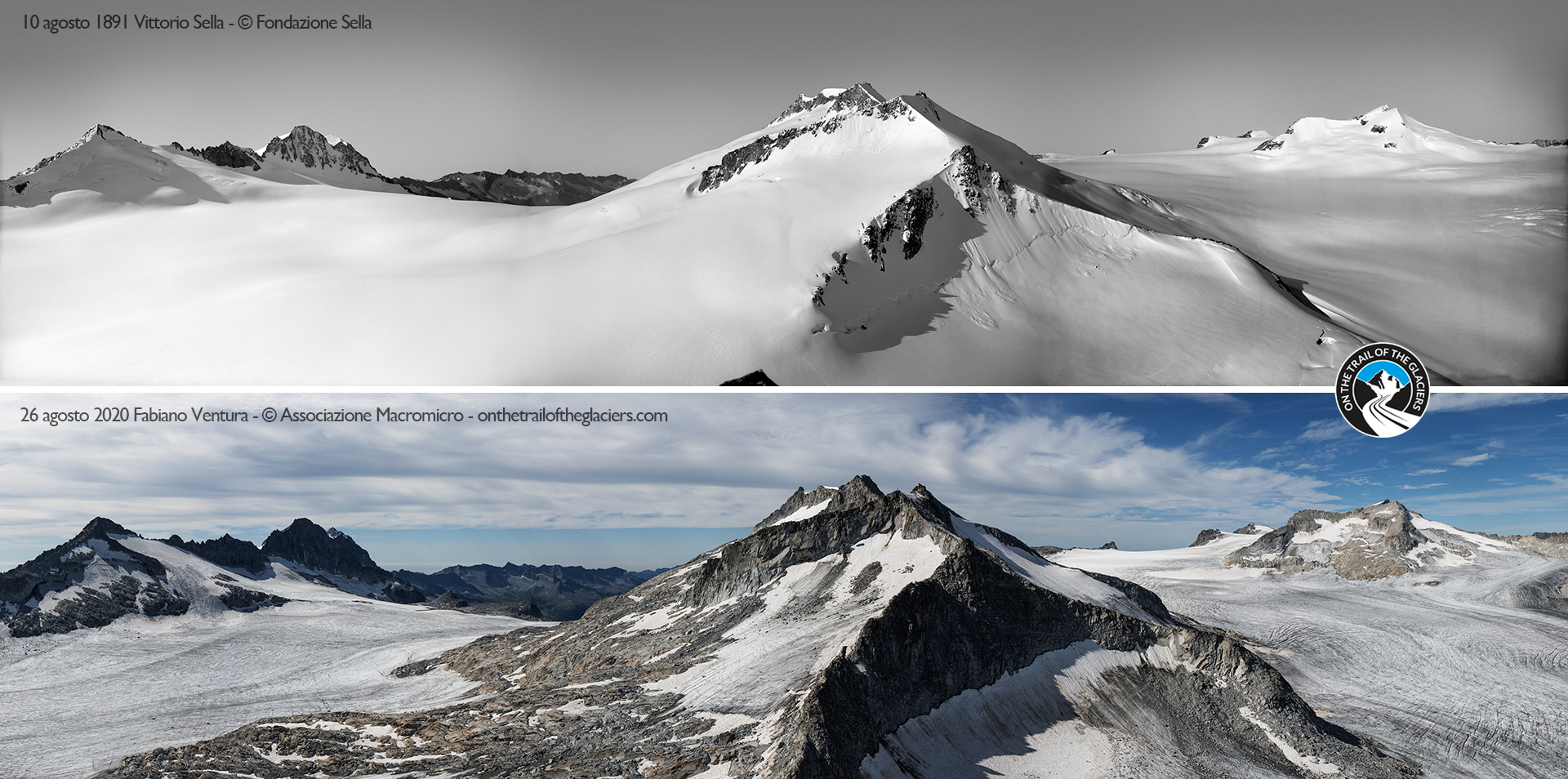
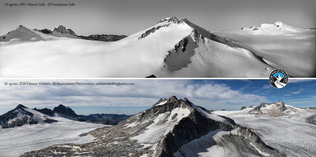
April: Adamello Glacier
With a surface area of 17 km2 and an estimated volume of 2 km3, the Adamello Glacier, located on the border of the regions Lombardy and Trentino, is the biggest of its kind in the Italian Alps. It comprises six units, i.e. Pian di Neve Plateau, Miller Superiore, Salarno, Adamé, Corno di Salarno, Mandrone, which together represent 1/4 of Lombardy’s glacier area and extends several hundred meters in altitude (2530 m – 3440 m a.s.l.) with an estimated maximum ice thickness of 260 m.
In recent years it has lost much of its area and ice mass due to increasing air temperatures, surface albedo feedback loops and a decrease in snowfall that could slow down its melting. Snow melt onset has shifted from mid-May to mid-April and no ice accumulation has been recorded in the last two decades. Since the Little Ice Age (14th – 19th century), the retreat of the Adamello glacier ice sheet is estimated to be 2.1 km in length and 900 m in height.
The comparative pictures show the glacier in August 1891/2020 and are courtesy of the On the Trail of the Glaciers project, promoted by the non-profit association Macromicro.
Glaciers are shrinking in size and mass worldwide. This is a story about one of these glaciers: the Adamello Glacier in the Italian Alps. It explores an intimate visit to this ice giant and reflects on its fate of melting and contamination. While doing so, it also contemplates on how we as a human community may change our relation to the glaciers of this world and what it would mean if we gave them a space in our hearts in addition to our minds.
This project was realized as part of the Master’s Degree of Environmental Humanities at the Ca’ Foscari University of Venice.
Click on the link below to read “On the Death of a Glacier”
Author: Tim Jonay Gutsche
-
March: Rhône Glacier
The Rhône Glacier, which extends from 2197 to 3600 m a.s.l., is located in the Valais, a canton in southern Switzerland, near the Italian border. The glacier has an average width of around 2 km and covers an area of approximately 17 km2. It is the largest glacier in the Urner Alps and the source of the Rhône river, which flows to the Mediterranean Sea.
In the 19th and early 20th centuries, the glacier was a major tourist attraction due to its tongue, which back then reached far down into the valley at Gletsch. The glacier is rapidly shrinking and is now only the fifth largest glacier in Switzerland.
In recent decades, the glacier has lost a considerable amount of its mass due to climate change. Its surface is dominated by large crevasses and ice caves. The melting of the glacier ice and the change in runoff regimes are causing serious geo-hydrological problems.
We owe these wonderful images to Hugues Thiebault, member of Mountain Wilderness France, and to his great-grandfather Emmanuel Bigeard, moved by a passion for the mountains that has been passed down through the centuries.
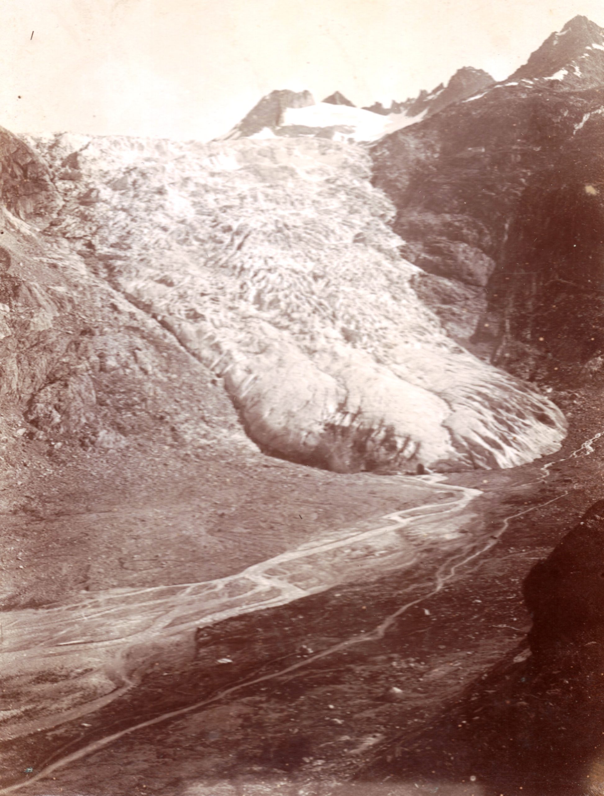
1898. Courtesy of Emmanuel Bigeard 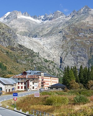
2023. Courtesy of Hugues Thiebault
-
February: Aneto Glacier
Aneto is the highest mountain in the Pyrenees and in Aragon, reaching a height of 3,404 m a.s.l. It stands in the Spanish province of Huesca, within the Posets-Maladeta Natural Park, just 6 km south of the French border. It forms the southernmost part of the Maladeta massif, which accounts for more than half of all glaciers in Spain, all located in the Pyrenees.
Its northern side holds the largest glacier in the Pyrenees, covering <0.5 km2 in 2022. The Aneto glacier is shrinking rapidly due to rising summer temperatures and reduced winter precipitations over the 20th century: it covered 1.067 km2 in 1981 and 0.79 km2 in 2005. It is estimated that it has lost more than half its surface area in the last 100 years, and that it may disappear around 2050.
Glacier surface loss in the Pyrenees is remarkable: there were 52 glaciers in 1850 and only 21 in 2020, corresponding to an area of 20.6 km2 and 2.3 km2 respectively, representing a loss of nearly 90% of the glaciated area.
1986. Courtesy of Jordi Camins 
2002. Corutesy of Jordi Camins
-
Glacier of the month, January: Glacier des Bossons
Many glaciers have been observed in their historical evolution. A paradigmatic case is Glacier des Bossons, in the Mont-Blanc massif. Since its tongue arrived close to Chamonix village in the past, paintings and pictures of its aspect a century or longer ago have been compared with recent pictures quite often.
In this case we will show side by side pictures taken in 1987, after the last oscillation, and in 2011.
Bossons Glacier in 1987. Picture taken from http://glaciers-climat.fr/Bossons/Glacier_des_Bossons.html 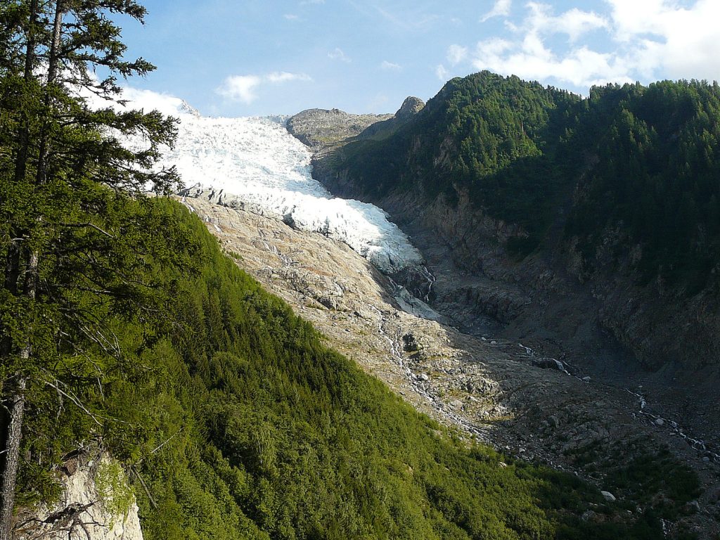
Bossons Glacier in 2011. Picture taken from https://www.camptocamp.org/articles/189798/fr/glacier-des-bossons-evolution